Alaska Mining History
Alaska has a rich mining history. Placer gold exploration and mining began in the area with the Russian explorers in the early 1800s. After acquisition by the United States, exploration and mining continued and gradually increased for both hard rock and placer minerals.
 The discovery and development of the A-J and Treadwell gold deposits eventually led to the location of the State Capitol. This was followed by the discovery of the Fortymile, Central, Nome, Fairbanks, Iditarod, and many other significant placer gold districts.
A young mining engineer by the name of George Pilz, while exploring southeast Alaska, offered a reward to any local native chiefs who could show him a gold deposit. Chief Kowee of the Auk Tlingit arrived with ore samples from the Gastineau Channel and Pilz hired Joseph Juneau and Richard Harris to do additional prospecting. Juneau and Harris found a large gold deposit at the head of what was to be named Gold Creek. This became the A-J Mine. The Treadwell mine was also developed in the area.
The Juneau mining district has produced 8.7 million ounces of gold up to 2005, including that from the rich Greens Creek mine. Turnagain arm was experiencing a gold rush in 1895 and this led to the development of two towns, Hope and Sunrise. The Turnagain arm has experienced over 100 years of varying activity and has produced 134K ounces of gold.
Identifying natural and emerging hazards
In Alaska each year, natural hazards may cause deaths and can cost millions of dollars due to the disruption of commerce, and the destruction of critical infrastructure. The USGS ASC science helps forecast and mitigate disasters and build resilient communities through cutting edge science, research, and monitoring tools and techniques pioneered here for Alaska’s diverse and challenging landscape. Monitoring programs that address natural and emerging hazards include:
- Monitoring volcanoes through the Alaska Volcano Observatory, a cooperative program of the USGS, University of Alaska Fairbanks Geophysical Institute, and the Alaska Division of Geological and Geophysical Surveys.
- Operating a streamflow monitoring network for flood warning and mitigation.
- Tracking emerging wildlife diseases, such as Avian Influenza (Highly Pathogenic H5N1) in migratory birds.

Providing the science for conservation and management of trust lands and trust species
Agencies of the Department of the Interior (DOI) manage more than 200 million acres of trust lands in Alaska. These include the lands and waters of National Parks, National Wildlife Refuges, Bureau of Land Management units, and Federal offshore areas. The USGS ASC provides the science for the management of Alaska’s Federal trust lands and waters, including:
- Long-term inventory and monitoring
- Focused scientific study
- Digital elevation models
- Landcover and geological maps
- Studies of wildlife-habitat interactions
- Effects of climate change
Assessing mineral resources
Evaluating Mineral Locations
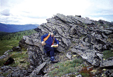
The USGS ASC conducts studies to gain a better understanding of the mineral-resource and mineral-environmental potential of all public lands in Alaska to provide information for land planners and decision makers about where mineral commodities are known and suspected in the Earth’s crust and about the environmental consequences of the presence of those commodities. Studies focus on:
- Bedrock and surficial geologic mapping
- Rock and stream sediment geochemical surveys
- Airborne and ground geophysical investigations
- Mineral resource assessments
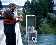
Assessing Water Quality
The USGS ASC monitors streamflow at more than 170 locations to:
- Monitor and forecast flooding and streambed scour
- Predict the magnitude and frequency of extreme events
- Provide hydrological assessments for water resources development
- Describe the status and trends in the quality of water resources
- Assure minimum instream flows for fisheries
Monitoring and modeling stream-channel erosion and morphology is critical for communities located on the banks of unstable rivers. Hydrological assessments and ground-water modeling can assist in evaluating water availability for communities and natural resource development.
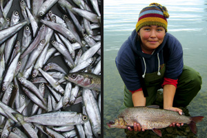
Investigating Aquatic Ecology: Juvenile Salmon; Whitefish
USGS ASC provides research support for the protection of the health of Alaskan waters and their inhabitants. USGS ASC conducts fisheries research on public lands and waters. National parks, refuges, and preserves are homes of lakes, rivers, estuaries, bays, and marine waters that provide recreation, commercial uses, and subsistence. Topics include:
- Fish and other aquatic species for subsistence, commercial, and sport harvest
- Environmental conditions that affect aquatic populations
- Habitat use in rivers, estuaries and coastal areas
- Communities and human health
- Water temperature
- Changes in sea ice extent
- Coastline erosion
