Chapter 18: Hawaii

Teaching With Documents:

Migration North to Alaska

Background


Cancelled Check for the Purchase of AlaskaNational History Day's 1998 theme encourages students to investigate topics related to Migration in History: People, Ideas, Culture.

Records held by the National Archives and Records Administration document many such migrations and provide countless suggestions for project topics.

The Gold Rush The following photographs, letters, drawings, and acts highlight some of the economic, social, and political factors that prompted thousands to migrate . . .

The Alaska Gold Rush

In 1880 Joe Juneau discovered gold in the Silverbow Basin of Alaska. This discovery, and subsequent discoveries in the Klondike, Yukon region, and elsewhere prompted thousands to migrate to the territory hoping to strike it rich.

The National Park Service provides valuable information on the Alaska Gold Rush.The Klondike Gold Rush National Historic Park and Klondike Gold Rush Seattle Unit National Historic Park also provide useful information.


The Documents

Over Chilkoot Pass During the Gold Rush in Alaska


Klondike Outfits at Dyea, 1898,
Starting point for the trail to the Northern Gold Fields

http://www.archives.gov/education/lessons/alaska/

An Overview Of Its Political History

"How firm we stand and plant our feet upon our land determines the strength of our children's heartbeats."
Polly Koutchak, Unalakleet

Alaska Native Peoples

The land now known as the state of Alaska has been continuously inhabited by Native peoples for thousands of years: the Tlingit, Haida, and Tsimshian of the southeastern coastal rainforest; the Athabascan tribes of the interior; the Aleut people of the Aleutian Chain and Pribilof Islands; the Yup'ik people of the Yukon-Kuskokwim Delta and coastal southwest Alaska; and the Inupiat of the northern coast of the Chukchi and Beaufort Seas. The Aleut word alaxsxag or agunalaksh, meaning the "great land" or "shores where the sea breaks its back" may be the source of the name "Alaska." The Aleut people have lived in the Aleutian Islands for more than 9,000 years, "a longer continuous existence as an identifiable people in one place than any other people in the world." The Native peoples of Alaska, comprising distinct languages, cultures, and traditions, share a close connection with the land and sea. As Justice Thomas Berger writes in Village Journey: "The traditional economy is based on subsistence activities that require special skills and a complex understanding of the local environment that enables people to live directly from the land." Subsistence is a word used to describe the hunting, fishing, and gathering traditions of Alaska Native peoples that includes the cultural and spiritual values of respect, sharing, love of the land, and integral relations among humans, animals, and the environment. "If you respect things and look at them as having a spirit or being, then you're in a place where you're at a balance. You look at the world that way and respect it and you see that it's providing you with a way of life, and your kids."Gabriel George, Angoon.

History of Exploitation

Alaska's recent history of the last 250 years is punctuated by a series of boom-and-bust cycles of exploitation of natural resources by European and European-American colonists in search of fur, whales, gold, copper, salmon, and oil. Promyshlenniki, or Russian fur traders, arrived in Alaska in the 1740's. Traders from Siberia exploited the superior kayaking and hunting skills of the Aleut people by forcing them into slavery to kill sea otters from Alaska to Baja California. In the sixty years following Vitus Bering's claim of Alaska for Russia in 1741, the Aleut population declined from 15,000 to 2,000. People died from European diseases such as smallpox and measles for which they had no immunity. The northern coast of Alaska was invaded by the "original oil men from the South," the Yankee whalers in search of whale oil and baleen, who nearly decimated the bowhead whale population in the Beaufort and Chukchi Seas in the mid-1800's.

As Russia wiped out the sea otters, its interest in Alaska waned. In 1867, the Tsar of Russia reached an agreement with then U.S. Secretary of State William H. Seward to sell Alaska to the United States for 7.2 million USD, about 2 cents per acre. Seward was widely criticized for the deal to acquire what some perceived as a frozen wasteland and the agreement became known as "Seward's folly." For Seward, the agreement fulfilled his dream of manifest destiny. The sovereign rights of the Alaska Native peoples were ignored in the transaction.

In the decades that followed, gold strikes began in southeast Alaska and expanded into Interior Alaska and to the Bering Sea around Nome. The gold rush rapidly transformed Alaska. Outsiders with gold fever now numbered in the thousands. Early efforts to establish Alaska as a state failed, although in 1906 Alaska had a non-voting delegate in the U.S. House of Representatives. Railroads and roads were built to facilitate the export of gold, copper, and coal.

World War II and the Cold War highlighted Alaska's strategic importance and ended the Territory's political isolation. In 1942, the 1,400 mile Alaska Canada Military Highway between Dawson Creek, British Columbia and Delta Junction near Fairbanks, was built in 8 months at a cost of $138 million. Alaska's strategic military significance and growing economic importance with the prospect of oil, prompted Congress to approve Alaska's statehood in 1958. Alaska became the 49th state.

Oil!

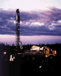
In 1902, the New York Times reported: "An immense oil gusher was struck at Cotella [sic] on the south Alaskan coast. An important new industry is thus added to Alaska's resources." The Katalla discovery, about 110 miles southeast of Valdez, only resulted in a local boom and dreams were dashed when the small refinery was destroyed by fire in 1933. The search for commercial discoveries of oil had begun. Irene Ryan, a geological engineer and bush pilot stated: "I felt people should be looking for oil instead of gold. Everyone thought I was nuts."

In the early 1950's, nationalization of Iran's oil fields and attempts to close the Suez Canal led oil companies to seriously approach potential oil reserves in Alaska. Oil companies began to purchase vast acreage in oil leases, with over 5 million acres leased by the end of 1955. After about 165 consecutive oil well failures by oil companies in Alaska, Richfield, a small California company that later merged with Atlantic Refining and became ARCO, struck oil in the Swanson River area of the Kenai Peninsula in 1957. The well soon produced 900 barrels of oil per day, the first commercially productive well in Alaska. The Kenai Peninsula and Cook Inlet region became an important producer of oil and natural gas, with 15 offshore oil platforms, on-shore oil and gas production, large processing, refining, and transportation facilities.

Atlantic Richfield struck an 'elephant' field at Prudhoe Bay along the Beaufort Sea coast in 1968. With a capacity of 10 billion barrels, it became the country's largest oilfield. Oil companies honed in like sharks. In 1969, Alaska received over $900 million in one oil lease sale alone. Five years after the Prudhoe Bay discovery, Congress approved construction of the Trans-Alaska Pipeline System (TAPS), with then Vice-President Spiro Agnew casting the deciding vote in the United States Senate. The pipeline, operated by a consortium of seven oil companies forming Alyeska Pipeline Service Company, traverses 800 miles from Prudhoe Bay to tidewater in Valdez on Prince William Sound. On June 20, 1977 the first oil from Prudhoe Bay flowed southward. At peak capacity, TAPS carried 2 million barrels of oil per day. Nearly one-tenth of the crude oil consumed in the United States flows from Prudhoe Bay through TAPS.

Alaska Native Claims Settlement Act

Oil companies lobbied hard for the passage of the Alaska Native Claims Settlement Act (ANCSA) because they feared that Native claims along the proposed TAPS route might prohibit the granting of right of way. ANCSA, passed in 1971, gave Alaska Natives title to 44 million acres and $962 million to settle aboriginal land claims. ANCSA was the largest land claim settlement in U.S. history. Each Alaska Native became a stockholder and received 100 shares in one of twelve regional corporations. ANCSA was set up for failure. ANCSA was negotiated by few who did not represent most Alaska Native people. As Lillian Liliabas questioned: "Who voted for ANCSA? You won't find ten people on the Kuskokwim who voted for ANCSA." "The imposition of a settlement of land claims that is based on corporate structures was an inappropriate choice. The village has lost its political and social autonomy."-Justice Thomas Berger

Alaska Native tribes are asserting their rights to protect their lands and subsistence way of life through legal and political avenues. The recent Venetie decision by the US Ninth Circuit Court of Appeal, establishes that ANCSA did not extinguish Indian country and that the village of Venetie has the right to impose a tax on an outside contractor. This decision has sparked racist fearmongering, especially from politicians who represent corporate interests. The Governor and the state legislature appropriated $1 million to appeal the decision to the U.S. Supreme Court.

Politicians Bought and Sold

Fully 85% of Alaska's government revenue comes from the oil and gas industry. Industry contributions also fill a hefty portion of the politicians' campaign chests. Many Alaskans are lulled into complacency with the average of about $1,000 per year return on the Permanent Fund Dividend, a state-managed trust fund created from oil royalties. In turn, the oil industry receives little scrutiny from state and federal regulators.

The lack of government oversight of the oil industry in Alaska has created serious problems that threaten the environment, human health and safety. The tragic Exxon Valdez oil spill that poisoned over 1,000 miles of Alaska's coastline was a culmination of government complacency. A recent report commissioned by the Alaska Forum for Environmental Responsibility concludes that "Alyeska's efforts are not sufficient to protect the environment TAPS crosses, and the health and safety of its workers, from the risks of an aging pipeline." Oil companies in Cook Inlet committed thousands of violations of their Clean Water Act permit from 1987-1995. With a special exemption for Cook Inlet, EPA allows the oil industry to dump millions of pounds of toxic waste each year.

Despite its failure to act responsibly, the industry is granted access to virtually the entire coastline of the Beaufort Sea and Cook Inlet through special area-wide state and vast federal lease sales. The state has spent millions of dollars to lobby Congress to open the Arctic National Wildlife Refuge to oil development, a move supported by Alaska's Congressional delegation. Meanwhile, the industry encroaches on the borders of the Refuge through its Warthog, Sourdough, and other prospects. The Minerals Management Service is offering lease sales in the Chukchi, Beaufort, Gulf of Alaska, and Cook Inlet. Plans to open the National Petroleum Reserve are also proceeding


http://archive.greenpeace.org/comms/97/arctic/library/region/native.html

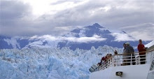
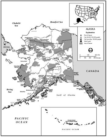
The Geography of Alaska

Alaska's Location

Relative location tells us where something is in relation to other places. In the 1930’s, General Billy Mitchell claimed that Alaska was the center of the world. Of course, at the same time, most Alaskans thought of their semi-isolation and considered their territory as being near the ‘edge’ of the world.

Absolute location refers to a geographic address. For many Alaskans their mailing address is one way they answer where exactly they are at. Of course, that location might be a post office box address: P.O. Box 1, Any City, Alaska. That address places those people at the local community U.S. Post Office. For others, that address might be a street address: 100 West Main Street, Anytown, Alaska. We will look at other ways of identifying exact location below.

Together, these location systems—relative and absolute—provide us with a way of understanding where we are in the world.

Relative Location: Where is Alaska?

What could General Mitchell possibly be thinking of when he made his claim that Alaska was at the center of the world? General Mitchell had spent part of his military career in Alaska. He was involved with the Signal Corps so he knew something about the territory.

He also had a fascination with aircraft and felt that the U.S. military needed to bolster its air force. (At the time, there was no U.S. Air Force.)


Figure L.1 - Alaska from Space. Orthographic projection.
General Mitchell looked at Alaska on a globe. He saw that Alaska was approximately equal distance from all of the major urban-industrial centers of the world. Figure L.1 is a map of Alaska as seen from space. It is centered on Lake Minchumina in Interior Alaska. Note that we can see the major centers of Asia (Tokyo and Bejing are shown), Europe (Moscow, Berlin, Paris, and London are shown), and North America (New York, Toronto, and Los Angeles are shown). General Mitchell viewed Alaska’s relative location and found that it was, indeed, central to the urban-industrial world.

We can view Alaska’s relative location from a number of perspectives. For simplicity, we will identify Alaska as part of the North Pacific, the Northern world, the North American continent, and the United States.

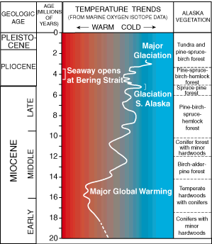
North Pacific. The commonly accepted theory of the initial occupation of Alaska is that people migrated from Asia over different periods of time. One advantageous time period was during the Pleistocene glacial period when the vast area of Beringia existed. People could move along the coastline from one continent to the other as the water barrier was non-existent. Of course, even the waters of the Bering Strait have proven to be no real barrier to Inupiat and Chukchi peoples who have moved back and forth between North America and Asia for centuries.


Figure L.2 - The Near Islands of Alaska
When Alaska was known as “Russian America” its relative location was different than today. The Russians named part of the Aleutian Islands the “Near Islands.” We certainly do not think of Attu Island as “near” to the rest of Alaska or the United States. But, it was near to Russia. Attu Island was controlled by the Russian America Company (Figure L.2).


Figure L.3 - Alaska as part of the North Pacific region
Today, Anchorage International Airport is one of the busiest air cargo ports in the world, handling cargo between Asia, Europe, and North America. Alaska’s location along a convenient North America-Asia Great Circle shipping route was well understood by both the Russia America Company and the U.S. government in the 19th century (Figure L.3).

Northern World. If we look at Figure L.1 again, we can see how Alaska is part of the Northern world. We share the Arctic Ocean waters with Russia, Sweden, Norway, Greenland, and Canada. The Arctic Circle, an arbitrary line of latitude at 66.5° North, crosses all of the above countries plus Finland (which is blocked from the Arctic Ocean). Thus, all of these countries (and Alaska) share a similar environment. International conferences on changing northern climate and permafrost draw participants from across the northern world. Similarly, institutions have been formed that are founded on the shared northern situation. Examples include the Arctic Council (amongst countries) and the Northern Forum (amongst northern regional governments such as Alaska).

This is a good place to pause and consider Alaska’s relative size. Alaskans are proud of the size of their state—589,000 square miles or over three times the size of California. Yet, in the context of the northern world, its size is modest, being exceeded by regions such as the Northwest Territories and Nunavut in Canada, Greenland, and Sakha in Russia.


Figure L.4 - Alaska as Part of North America
North America. Alaska is also part of North America. (Figure L.4) Indeed, it is physically attached to North America, sticking out at the northwest portion of the continent as a large peninsula. Alaska’s linkages with the rest of North America are many. In physical geography the examples include mountain ranges (Rocky Mountain and Coastal Mountain systems), climate (arctic and sub arctic), glaciers, vegetation (tundra and boreal forest), and animals (moose, raven). In human geography the examples include centuries of dispersal of Inupiat and Athabaskan peoples. Alaska’s transportation linkage with the rest of North America became a reality in World War II with the completion of the Alaska Highway. At that same time an oil pipeline was completed to Alaska; however, it linked only the Northwest Territories (Norman Wells), the Yukon Territory, and Alaska. The line did not link to the main distribution lines of North America. Yet, today, discussions for future linkages of Alaska with the rest of North America include a railroad and a natural gas pipeline.

United States. Since 1867, of course, Alaska has been part of the United States, and since 1959, it has been a state within the United States. Alaska accounts for 17 percent of the total U.S. area and 64 percent of the U.S. coastline. Along with Canada, the U.S. borders on the Arctic Ocean, Pacific Ocean, and Atlantic Ocean.

Where in Alaska?

We have looked at Alaska relative to other places and regions. But within Alaska we can see how a relative location perspective can be very helpful. Imagine you are a high school student from California attending a meeting or a sporting event with students from other areas of the western states. You happen to sit at a table for dinner with students from Barrow, Fairbanks, and Ketchikan. To start the conversation, you ask the polite question, “What’s it like in Alaska?” Image the different responses you would get! You might be inclined to ask if the three students were, in fact, from the same state. The shear size and distances between places account for the great differences between places. Additionally, there are great environmental differences between these areas that are separated by mountain ranges and 15 degrees of latitude.


Figure L.5 - Distances in Alaska
Air travel. Figure L.5 provides a way of grasping the distances between places in Alaska. While large, the distances are reduced if one thinks of air miles by plane. Anchorage is just over an hour and a half from Juneau. Nome is just over an hour from Anchorage by air. Adak is over 4 hours from Anchorage by air. However, when one considers weather delays, the times could be greatly extended. Travel between Anchorage and Unalaska is sometimes delayed for days because of weather.


Figure L.6 - Alaska’s Transportation System
Since Alaska has few roads, the sense of remoteness is often amplified. This is especially true in much of the rural portion of the state where there are no roads connecting to the main Alaska Highway grid (Figure L.6). The capital, Juneau, is inaccessible by road, unless, of course, one includes the Alaska Marine Highway. Even then, one has to travel to Canada in order to enter the Southeastern Panhandle region of the state.


Figure L.7 - Alaska’s center points.
Center points (Figure L.7). Another way to view relative location is to consider where Alaska’s center points are found. If we were to cut out a map of Alaska from a piece of paper and balance the map on the point of a pencil, we would have found the center point of the physical structure of the state. That point is at 63°50’ N, 152° W. or near Lake Minchumina. In a similar way, if we were to find the center for the population of Alaska (based on the numbers of people in each settlement) Anchorage would be the center of the state. Lake Minchumina is 205 miles to the northwest of Anchorage.

Absolute Location

In contrast to relative location which compares a location with what surrounds it, absolute location refers to exact location. We can express this location mathematically using different geographical systems.

Latitude and longitude is the most commonly used system. It is based on degrees of latitude (90° north and 90° south with the center at the Equator) and longitude (180° east and 180° west calculated from the Prime Meridian). This location system divides each degree into 60 minutes and each minute into 60 seconds. If you wanted to identify the National Park Service headquarters for Denali National Park it would be:

63° 43’ 20” N, 148° 57’ 48” W

According to this system, Alaska has the distinction of being in both the eastern and the western hemisphere. The Rat Islands and Near Islands lie in the Eastern Hemisphere. Thus, Alaska is sometimes the subject of trivia game questions: “What is the northernmost, westernmost, and easternmost state of the United States?”

Using this system, we can see that Alaska extends over a vast area. Here are its key extents:

South: 51° 13’ N. at the tip of Amatignak Island in the Aleutian Islands
North: 71° 23’ N. at Point Barrow
East (towards Canada): 129° 59’ W. at Cape Point in Southeast Alaska
West (towards Russia): 172° 27’ E. at Cape Wrangell on Attu Island

While the distance between the northern and southern points is 1,420 miles (2,285 km) and the distance between the eastern and western points is 2,400 miles (3,862 km), Alaska definitely does not have a neat rectangular shape. The Aleutian Islands extend out so far from the main body of Alaska that they are rarely shown on maps in their proper location. Not surprisingly, Alaska’s 6,640 miles (10,700 km) of coastline amount to over half of the total coastline of the United States.

Alaska’s size, by U.S. standards, is enormous. It accounts for 16 percent of the U.S. area. More specifically, Alaska’s 589,194 square miles (1,525,953 km2) consists of 571,951 square miles of land (1,481,296 km2) and 17,243 square miles (44,658 km2) of inland waters.

http://www.akhistorycourse.org/articles/article.php?artID=121

Chapter 16: The North Pacific Coast

National forests

Tongass and Chugach are both playgrounds and timber producers

Alaska has two national forests, the Chugach and the Tongass.

They're used extensively for all kinds of recreation, from fishing and hunting to mountain biking and snowmobile riding.

Chugach National Forest covers much of coastal Southcentral Alaska, including part of the Kenai Peninsula, the area around Prince William Sound and the Chugach Mountains south of Anchorage.

• Tongass National Forest covers the islands and mainland of Southeast Alaska's Inside Passage.

The forests, established in 1907, both serve a number of uses, such as logging, recreation and subsistence.

The Chugach covers 5.9 million acres, or 9,300 square miles (roughly equivalent to Vermont). The Tongass covers 16.6 million acres, or 26,500 square miles (West Virginia).

Two national monuments -- Admiralty Island and Misty Fjords -- are found in the Tongass. There are numerous other wilderness areas.

The forests offer lots of pleasure for residents of and visitors to Southcentral and Southeast Alaska: hiking, camping, fishing, birding, hunting, snowmobiling, skiing, canoeing and river running, mountaineering and glacier viewing.

Remote public-use cabins are available for a small fee, although flying, hiking or boating to them may be expensive or time consuming.

http://www.alaska.com/national-forests/

Fishing in Alaska

Two fishing derbies -- for king and silver salmon -- are held each summer in downtown Anchorage. Ken Scott of Phoenix fishes for silvers at the mouth of the creek as it empties into Cook Inlet.

Anglers will have their hands full

Fishing in Alaska is different from fishing anywhere else in the world.

It's an angler's dream.

There are five kinds of wild Pacific salmon (king/chinook, silver/coho, red/sockeye, pink/humpback, and chum), plus halibut the size of barn doors, rainbow trout that weigh 15 pounds, and delicate arctic grayling that slash at flies.

Altogether, Alaska has 21 recognized species of sport fish in its streams, lakes and oceans.

Fishing in Alaska can be as easy as buying a license and heading for a stream or lake -- or it can be a daylong boat charter in Prince William Sound or a week's worth of fly-in remote backcountry action where anglers watch for fish and for bears.

http://www.alaska.com/activities/fish/

Alaska - Economy

When Alaska gained statehood in 1959, its economy was almost totally dependent on the US government. Fisheries, limited mining (mostly gold and gravel), and some lumber production made up the balance. That all changed with development of the petroleum industry during the 1970s. Construction of the Trans–Alaska Pipeline brought a massive infusion of money and people into the state. Construction, trade, and services boomed—only to decline when the pipeline was completed.

In the mid-1980s, the economy was dependent on government spending, especially by the state, and on the oil industry, which by 1984 supplied 85% of state revenues. The collapse of the oil prices in the mid-1980s hit Alaska hard. Employment dropped 9.4% between 1986 and 1988. By 1990, a recovery was underway. Accumulated gains in employment, while small, more than compensated for the losses of a few years before.

One area of growth in the 1980s and early 1990s was the Alaska groundfish industry. Commercial fishing is one of the bulwarks of the Alaska economy. The seafood industry had wholesale values of more than $3 billion in 1990, and Alaska's fishery accounts for 50% of the total annual US catch. The volume of Alaska groundfish catches rose from 69 million lb (31.3 million kg) in 1980 to 4.8 billion lb (2.2 billion kg) in 1990. Employment in seafood harvesting grew from 45,000 in 1980 to 54,000 in 1991, although the boom has slowed somewhat since.

Retrenchment of oil and gas companies reduced mining jobs by 11% in 1992. Log exports began to decline in 1990 and were expected to drop 50% by 1997 as the supply of timber shrank. In 1993, the state sued the federal government for violating the Statehood Act. The act had entitled Alaska to 90% of the revenues from mineral leasing on federal lands. Since passage of the Act, however, half of the federal lands had been withdrawn from mineral leasing. Job creation rates, which ranged from 2% to 4% in the early 1990s, rose and fell from nearly 3% to less than 1% for the rest of the decade roughly in line with the rise and fall in North Slope oil prices, which hit troughs in 1994 and 1999 (during which the oil price hit a low of $12.73 a barrel). Gross state product fell 7.2% in 1998, but then increased 3.6% in 1998 and then soared 10.1% in 2000. In 2000, Alaska oil revenues still accounted for almost 85% of total state revenues, although low oil prices and production during the late 1990s threatened to lower this percentage. The tourism industry attracted over 1.1 million visitors in 2000, and contrary to national trends, continued to expand into 2002. The number of inbound cruise ship visitors, for example, increased 14% from summer 2001 to summer 2002. Other important industries include timber, mining (including gold, coal, silver, and zinc), and agriculture. The national recession of 2001 reduced gross state product growth to 1.6% and slowed employment growth to less than 1% in early 2002, again in line with sharply falling oil prices. Loan delinquency increased, with the median past-due loan ratio rising from 1.52 % to 1.62% from September 2001 to September 2002. From 1997 to 2002 increased environmental regulations and foreign competition from, particularly, Chile and Norway, contributed to a decline in employment in the traditional seafood packing industry of more than 15%. On the other hand, employment in both state and local government, and in the hotels and lodging industry increased by almost 15%. Employment in the oil and gas extraction sector increased by about 5% 1997 to 2002, while employment with the federal government decreased almost 3%. In 2003, rising oil prices, reflecting political instability in Iraq and Venezuela and other factors, were expected to benefit the Alaskan economy

In 2001, Alaska's gross state product was $28.6 billion, with 19.5% accounted for by the public sector, the 2nd-highest percent among the states (after Hawaii), and well above the state average of 12%. Both mining and government contributed about $5.6 billion to gross state product in 2001, but for mining this represented a 19% decrease from 1997 and for government a 10.8% increase over the same period. Public utilities and transportation contributed $4.6 billion, up 15% from 1997. Both general services, contributing $3.96 billion, and the finance, insurance and real estate sector, contributing $3.2 billion, increased about 29% 1997 to 2001. Other important sectors included retail trade, at $1.9 billion (up 12% from 1997) and construction, at $1.4 billion (up 24% from 1997). The manufacturing sector contributed $1.06 billion, down 5% from 1997.

http://www.city-data.com/states/Alaska-Economy.html

Chapter 15: California

Alaska Regions & Popular Destinations

Alaska Peninsula at a Glance

The Alaska Peninsula, the state's southernmost region, extends roughly 500 mi (805 km) and offers a distinctive, isolated environment rife with natural wonders and some of the most scenic destinations in the United States. Home to a number of Alaska's large lakes, Katmai National Park can be found at the top of the peninsula and is known for its fishing and wildlife viewing opportunities. The park is also world famous as a place to witness brown bears feasting on salmon from local rivers. Adak is a town located near the end of the Alaska Peninsula in the Aleutian Islands. This town sits halfway between Seattle, Washington, and Japan, and is approximately 1400 mi (2253 km) from Magadan in Russia. Adak is a great destination for travelers seeking to immerse themselves in Alaskan isolation. Experience the secluded beauty that can only be found on the Alaska Peninsula.

Central Alaska at a Glance

Central Alaska is home to Denali National Park, a wilderness characterized by towering mountains, large glaciers and a host of wildlife. One of the most exciting ways to see the park is aboard a guided bus tour that ventures to an authentic wilderness lodge. Anchorage, Alaska's largest city and the center of commerce for the state, has a climate that is surprisingly moderate compared to the rest of Alaska. The world-famous Iditarod dog-sled race begins at Anchorage each spring. Amongst the region's most impressive attractions are the Anchorage Museum of History and Art, the Alaska Zoo and Chugach State Park. The main supply center for the oil industry and Arctic Alaska is Fairbanks, which is also located at the center of the state. Ester Gold Camp, a historic mining town established in the early 20th century, offers dinner buffets and saloon-style entertainment shows. A popular Central Alaska activity is boating on the Chena and Tanana rivers.

Juneau & Area at a Glance

The Juneau region's most well-known feature is the world-famous Inside Passage and Glacier Bay National Park—visited every summer by the world's luxury cruise ships. Fishing, camping, hiking and rafting are among the activities that attract visitors to the park. When in Juneau visit the interesting exhibits at Alaska State Museum and learn about the area's natural history, native peoples and Russian and American influences. The nearby historic town of Sitka is home to the Sheldon Jackson Museum, Alaska's oldest museum, and located close to Sitka National Historic Park, which features a number of intricate totem poles. The area is rife with tour companies that allow visitors to take in the scenery by plane, boat, bicycle and on foot. In addition to hotels, Juneau offers several bed and breakfast accommodations for visitors craving warm hospitality and home-cooked breakfast.

http://alaskapeninsula.worldweb.com/

The Great Alaska Earthquake of 1964

On March 27, 1964, at 5:36 p.m. ADT (03:36 3/28 UTC) a great earthquake of magnitude 9.2 (moment magnitude) occurred in Prince William Sound region of Alaska. The epicenter was about 10 km east of the mouth of College Fiord, approximately 90 km west of Valdez and 120 km east of Anchorage. The epicenter was located at Lat. 61.04N, Lon. 147.73W, at a depth of approximately 25 km. This earthquake is the second largest earthquake ever recorded in the world. after a M9.5 earthquake in Chile in 1960. The duration of rupture lasted approximately 4 minutes (240 seconds).

Cause

The northwestward motion of the Pacific plate at about 5 to 7 cm per year causes the crust of southern Alaska to be compressed and warped, with some areas along the coast being depressed and other areas inland being uplifted. After periods of tens to hundreds of years, this compression is relieved by the sudden southeastward motion of portions of coastal Alaska as they move back over the subducting Pacific plate.

As a result of the 1964 quake, the Latouche Island area moved about 18 meters to the southeast. Also, the patterns of uplift and subsidence which had been slowly developing prior to the earthquake were suddenly reversed, with areas around Montague Island being uplifted 4-9 meters and areas around Portage down-dropped as much as 3 meters. The hinge line (line of no vertical change separating the uplift and subsidence zones) extended from near the epicenter in Prince William Sound to the SE coast of Kodiak Island. This vertical deformation affected and area of approximately 250,000 km2 (100,000 miles2). The end results was the movement of the Pacific plate under the North American plate by about 9 meters on average.

Aftershocks


The six-story Four Seasons apartment building in Anchorage was completely destroyed. It was unoccupied at the time of the earthquake.


The aftershock zone of this earthquake was about 250 km wide and extended about 800 km from Prince William Sound to the southwestern end of Kodiak Island. The mainshock and its aftershocks occurred on a fault which is part of the boundary between the Pacific and North American plates. Thousands of aftershocks were recorded in the months following the mainshock. In the first day there were 11 aftershocks with magnitudes greater than 6.0; in the next three weeks there were 9 more. Smaller aftershocks continued for more than a year.

Damage

The area where there was significant damage covered about 130,000 square kilometers. The area in which it was felt was about 1,300,000 square kilometers (all of Alaska, parts of Canada, and south to Washington). The four minute duration of shaking triggered many landslides and avalanches. Major structural damage occurred in many of the major cities in Alaska. The damage totalled 300-400 million dollars (1964 dollars).

http://www.aeic.alaska.edu/quakes/Alaska_1964_earthquake.html


Alaska is still one of the most pristine areas in all the world, yet environmental problems frequently make the headlines. Air, water, soil and sound pollution affect areas throughout the state, even hundreds of miles away from civilization. Contaminated areas in Anchorage can affect areas in the Interior. For instance, traditional spawning areas for salmon can become highly contaminated with waste from nearby factories, sewage treatment plants, or pesticides from farms. The salmon come in to spawn as usual, but the salmon are killed due to the new contaminants. The eggs laid by the female salmon may get fertilized, but the salmon never reach a healthy enough state to make their return journey to the ocean. Native fishermen who rely on these salmon as a source of food must look else where. Thus, a whole village could be in jeopardy.

In the rest of this page you will learn of the different types of pollution and how it affects the land and people.

Types of Pollution
Definition
Types of Areas Affected
What it causes
Air Pollution An airborne substance that adversely affects the well-being of organisms or the life-support systems on which they depend. On or near environments that have a condensed way of living or where fossil fuels are used at an increasing rate. Acid rain, smog, change in temperature, damage growth of all plant life, lower air quality, water pollution.
Water Pollution A substance that changes the environment around water inhabitants. Places that have multiple ships that are operated on fossil fuels. Also, from garbage by irresponsible humans. Death of animals, lower quality of drinking water for animals and humans, plant life near shores to declines.

http://library.thinkquest.org/26020/pages/evir._problems/envi.problems.html

Chapter 14: The Southwest Border Area: Tricultural Development

Alaska - Ethnic groups

In 2000 Native Americans accounted for 15.6% of Alaska's population—the highest percentage of any state. Indians—primarily Athabaskan (14,520) and Tlingit-Haida (14,825)—living in southeastern Alaska (Alaska Panhandle) numbered around 29,345 in 2000. There are also small numbers of Tsimshian living in this area. Eskimos (45,919) and Aleuts (11,941), the other native peoples, live mostly in scattered villages to the north and northwest. Taken together, Alaska Natives were estimated in 2000 to number about 98,043, up from 86,000 (16%) in 1996. The Native Claims Settlement Act of 1971 gave 13 native corporations nearly $1 billion in compensation for

Alaska
exploration, mining, and drilling rights, and awarded them royalties on oil and the rights to nearly 12% of Alaska's land area.

In 2000, the black population was 21,787, or 3.5% of the total population, down slightly from 22,000 in 1990. Among those of Asian origin in 2000 were 12,712 Filipinos, 1,414 Japanese, and 4,573 Koreans; in the same year, the total Asian population was 25,116 and Pacific Islanders numbered 3,309. In 2000, of Alaska's total population, about 25,852 individuals were of Hispanic or Latino origin, with 13,334 of those claiming Mexican ancestry (up from 6,888 in 1990). Foreign-born persons numbered 37,170, or 5.9% of the population (up from 4.4% in 1990).

http://www.city-data.com/states/Alaska-Ethnic-groups.html

Alaska's statewide population increased by 6.6 percent, or 42,520 people, in the six years from July 1, 2000-July 1, 2006, based on new population estimates released in December 2006 by the U.S. Census Bureau.

The Alaska Department of Labor and Workforce Development utilized the federal figures to calculate growth estimates released today for the state and by boroughs, census areas and places.

The State of Alaska

The population gain in Alaska was slightly faster than the 5.9 percent growth in the same period for the United States as a whole. The number of people living in the state climbed from 627,533 at the time of the July 1, 2000, to a provisional July 1, 2006, estimate of 670,053 (see Table 1).

gif Table 1


Alaska's rates of change were an annual average of 1.1 percent per year for 2000-2006 and 1.0 percent for 2005-2006. Alaska is still number 47 in terms of population, larger than North Dakota, Vermont, the District of Columbia and Wyoming.

Currently growth in Alaska as a whole is primarily through natural increase. From July 1, 2000, to July 1, 2006, Alaska's natural increase (births minus deaths) added 42,571 people, while net migration (in-migration minus out-migration) accounted for a loss of 51 people. During 2005-2006, Alaska added 7,310 people through natural increase and lost 510 people to out-migration.

In the early 1990s, Alaska added about 9,600 people each year through natural increase. A gradual decline in fertility and a gradual increase in mortality tied to an aging population have resulted in a slowdown in natural increase to about 7,300 persons per year.

http://www.sitnews.us/0107news/012507/012507_alaska_population.html

Newborns account for state population growth

The population in Alaska reached an estimated 679,720 people as of July last year, the state said Monday.

The population was up 0.8 percent from a year earlier, or 5,210 more people, according to Greg Williams, the state demographer. That change reflected 7,770 more births than deaths during the year, and 2,560 more people leaving the state than moving to Alaska, he said.

Williams said the Alaska population has grown 8 percent since 2000, or 52,187 people, the same percentage growth as the U.S. population showed.

Among communities in Alaska, the estimated populations last July were as follows:

• Anchorage, 284,994 people, up 0.9 percent from a year earlier.

• Mat-Su, 82,515 people, up 3.5 percent.


• Kenai Peninsula Borough, 52,990 people, up 1.7 percent.

• Fairbanks North Star Borough, 89,896 people, down 1.6 percent.

• Juneau, 30,427 people, up 1 percent.

The greatest population growth last year came in the Denali Borough near Denali National Park. The estimated population was 1,848 people, up 4.8 percent.

The greatest decline was in Yakutat, with 592 people, down 4.3 percent.

Williams said that troops based in Alaska but deployed overseas are counted as being in Alaska in his estimates. "This means that the populations for the Fairbanks North Star Borough and the Municipality of Anchorage, where the main Alaska military bases are located, as well as other communities with a substantial National Guard presence, may be somewhat lower than these estimates indicate, depending on the current deployment of military and National Guard personnel," he said.

http://www.adn.com/news/alaska/story/725332.html

Immigration and Naturalization Operations in Alaska

Since 1980 there have been over twenty-five pieces of federal legislation affecting immigration and naturalization, including comprehensive acts passed in 1986, 1990 and 1996 and the national security legislation passed after the terrorist attacks of September 11, 2001. The overall effect of the legislation of the past two decades has been to place heightened controls on admission to the U.S. and to broaden the powers of law enforcement agencies in arresting and detaining foreigners. The legislation has been tied to, or paralleled, both national welfare reform and crime control efforts, particularly drug control—with much of the legislation in the 1990s reflecting a concern with aliens and criminal behavior and aliens and financial responsibility. Since 9/11, the concern has been terrorism.
The most recent data providing an overview of the work of forestalling illegal immigration and facilitating legal admission to the U.S. come from the former Immigration and Naturalization Service. Until this spring, INS bore primary responsibility for structuring immigration; facilitating naturalization—the process of acquiring citizenship—and arranging for the deportation of those who enter the country illegally. With the birth of the Department of Homeland Security, these functions have been split up and placed under several bureaus in the new department. (See accompanying article “Reorganization of INS.”) The data presented here reflect the old configuration.
In Alaska, the functions of the INS have been administered from Anchorage, where the district headquarters is located. As with most government operations here, INS functions involve relatively few people over a vast area. The agency has administered essentially the same range of programs and operations here as in more densely populated states, including enforcement operations.
The data in this article in general cover INS operations from FY 1999 through FY 2001—just beyond the date of the terrorist attacks. (The federal fiscal year ends September 30.) In addition, because of the reported broader use of detention powers by law enforcement in the months since 9/11, the article also presents figures on INS detention operations for Alaska through FY 2002.

Immigration and Naturalization

In FY 2001 the INS recorded the admission of 1,401 legal immigrants who declared Alaska as their intended state of residence. The most sizeable national groups came from the Phillippines (366), Mexico (126), Canada (94), Russia (89), and Korea (79).
There is a complex structure of categories and regulations governing naturalization, but in general legal immigrants are eligible to become U.S. citizens after five years of residency in the country. In Alaska, in FY 2001, 710 people were naturalized. Of these, the most sizeable national groups came from the Philippines (170), Korea (87) and Mexico (60).

http://justice.uaa.alaska.edu/FORUM/20/1spring2003/a_immigration.html

Chapter 13: The Empty Interior

Alaska Mining History

Alaska has a rich mining history. Placer gold exploration and mining began in the area with the Russian explorers in the early 1800s. After acquisition by the United States, exploration and mining continued and gradually increased for both hard rock and placer minerals.

Alaska Mining History PhotoThe discovery and development of the A-J and Treadwell gold deposits eventually led to the location of the State Capitol. This was followed by the discovery of the Fortymile, Central, Nome, Fairbanks, Iditarod, and many other significant placer gold districts.

A young mining engineer by the name of George Pilz, while exploring southeast Alaska, offered a reward to any local native chiefs who could show him a gold deposit. Chief Kowee of the Auk Tlingit arrived with ore samples from the Gastineau Channel and Pilz hired Joseph Juneau and Richard Harris to do additional prospecting. Juneau and Harris found a large gold deposit at the head of what was to be named Gold Creek. This became the A-J Mine. The Treadwell mine was also developed in the area.

The Juneau mining district has produced 8.7 million ounces of gold up to 2005, including that from the rich Greens Creek mine. Turnagain arm was experiencing a gold rush in 1895 and this led to the development of two towns, Hope and Sunrise. The Turnagain arm has experienced over 100 years of varying activity and has produced 134K ounces of gold.

http://www.alaskamining.com/alaskamininghistory1.html

Identifying natural and emerging hazards

In Alaska each year, natural hazards may cause deaths and can cost millions of dollars due to the disruption of commerce, and the destruction of critical infrastructure. The USGS ASC science helps forecast and mitigate disasters and build resilient communities through cutting edge science, research, and monitoring tools and techniques pioneered here for Alaska’s diverse and challenging landscape. Monitoring programs that address natural and emerging hazards include:

  • Monitoring volcanoes through the Alaska Volcano Observatory, a cooperative program of the USGS, University of Alaska Fairbanks Geophysical Institute, and the Alaska Division of Geological and Geophysical Surveys.
  • Operating a streamflow monitoring network for flood warning and mitigation.
  • Tracking emerging wildlife diseases, such as Avian Influenza (Highly Pathogenic H5N1) in migratory birds.

Providing the science for conservation and management of trust lands and trust species

Agencies of the Department of the Interior (DOI) manage more than 200 million acres of trust lands in Alaska. These include the lands and waters of National Parks, National Wildlife Refuges, Bureau of Land Management units, and Federal offshore areas. The USGS ASC provides the science for the management of Alaska’s Federal trust lands and waters, including:

  • Long-term inventory and monitoring
  • Focused scientific study
  • Digital elevation models
  • Landcover and geological maps
  • Studies of wildlife-habitat interactions
  • Effects of climate change

Assessing mineral resources

Geologist
Evaluating Mineral Locations

The USGS ASC conducts studies to gain a better understanding of the mineral-resource and mineral-environmental potential of all public lands in Alaska to provide information for land planners and decision makers about where mineral commodities are known and suspected in the Earth’s crust and about the environmental consequences of the presence of those commodities. Studies focus on:

  • Bedrock and surficial geologic mapping
  • Rock and stream sediment geochemical surveys
  • Airborne and ground geophysical investigations
  • Mineral resource assessments
Water and fisheries
Photograph
Assessing Water Quality

The USGS ASC monitors streamflow at more than 170 locations to:

  • Monitor and forecast flooding and streambed scour
  • Predict the magnitude and frequency of extreme events
  • Provide hydrological assessments for water resources development
  • Describe the status and trends in the quality of water resources
  • Assure minimum instream flows for fisheries

Monitoring and modeling stream-channel erosion and morphology is critical for communities located on the banks of unstable rivers. Hydrological assessments and ground-water modeling can assist in evaluating water availability for communities and natural resource development.

Photograph
Investigating Aquatic Ecology: Juvenile Salmon; Whitefish

USGS ASC provides research support for the protection of the health of Alaskan waters and their inhabitants. USGS ASC conducts fisheries research on public lands and waters. National parks, refuges, and preserves are homes of lakes, rivers, estuaries, bays, and marine waters that provide recreation, commercial uses, and subsistence. Topics include:

  • Fish and other aquatic species for subsistence, commercial, and sport harvest
  • Environmental conditions that affect aquatic populations
  • Habitat use in rivers, estuaries and coastal areas
  • Communities and human health
  • Water temperature
  • Changes in sea ice extent
  • Coastline erosion
http://pubs.usgs.gov/fs/2007/3019/

Chapter 12: The Great Plains And Praires

How Does Climate Change Influence Alaska's Vegetation?
Insights from the Fossil Record

Plant fossils, such as leaves, wood, cones, pollen, and seeds, provide important evidence of how Alaska's vegetation has responded to climate changes over time periods of centuries to millions of years. Long-term trends of global temperatures have been reconstructed from oxygen isotope measurements of microscopic fossils (foraminifera) in the Pacific Ocean (fig. 1). This temperature curve can be used to compare the major changes in Alaskan vegetation with global climate changes spanning the past 20 million years.
Figure 1
Figure 1. Pacific Ocean seawater temperature trends derived from measurements of oxygen isotopes in fossil marine organisms provide the climatic framework for interpreting the Alaskan fossil plant record.
USGS studies of the Alaskan fossil record of plants include data from many natural exposures and sediment cores (fig. 2). These data provide the basis for reconstructing the record of past vegetation changes over millions of years of Earth history. The fossil record shows that dramatic changes in high latitude vegetation have occurred many times in the past, primarily in response to global climate changes. The record further suggests that the magnitude of ecological response to global climate change is greater at high latitudes than at low latitudes. During the Miocene, a major global warming event occurred between 17 to 14.5 Ma (million years ago). In Alaska and in other high latitude regions of the world, this warming event profoundly changed vegetation from a conifer-dominated forest with few temperate hardwoods to a temperate forest containing many tree and shrub species now found far to the south in Asia and North America, such as oak, hickory, beech, chestnut, walnut, wing-nut, elm, holly, basswood, hazelnut, and sweetgum. In order for temperate vegetation to grow at such high latitudes, the mean annual temperature of interior Alaska must have been about 25-30° F warmer than today.

Global cooling began about 14.5 Ma, and its influence on Alaskan vegetation was abrupt and dramatic. Temperate trees disappeared, leaving behind a simpler forest vegetation of hardy birch, alder, and pine species until a more complex conifer-dominated forest developed after about 12 Ma. A series of cool climate pulses during the middle and late Miocene and late Pliocene eliminated additional tree species from Alaskan forests. Minor warming events about 11, 9, and 7 Ma reversed these trends slightly for brief periods, but the overall trend during the Miocene and Pliocene was the steady reduction in tree and shrub species, leaving hardy plant types that could grow in Alaska's progressively cooler climate. By the middle Pliocene, about 3 Ma, Alaskan vegetation began to resemble modern Alaskan boreal forests. Middle Pliocene forests were composed primarily of pine, spruce, larch, birch, alder, and willow, and with the exception of pine, these compose the vegetation found today in Alaska's boreal forests.

Figure 2
Figure 2. U.S. Geological Survey's global change drilling project at Fort Yukon, Alaska recovered a detailed record of climate and environmental change for interior Alaska spanning much of the past 16 million years.
Global climate changes during the past 2.5 million years have been extreme, oscillating between relatively long periods (ca. 100,000 years) of predominantly cold, dry glacial climates and shorter intervals (ca. 10-20,000 years) of warmer, moister interglacial climates. During full glacial intervals, mean annual temperature in interior Alaska declined about 9 to 15° F below modern temperatures. During cold periods, glaciers expanded from the 5 percent of Alaska they now cover to 30 to 50 percent of the present area of the State. When glaciers expanded and temperatures declined, tundra vegetation spread to lower elevations and forests were reduced to small areas in the eastern interior, and some tree species may have been eliminated entirely from Alaska (fig. 3).
During warm interglacial periods such the one we are currently experiencing (the Holocene, spanning the past 10,000 years), boreal forests of spruce, larch, poplar, birch, alder, and willow spread throughout most of interior Alaska. During the warmest part of the previous interglacial (about 130,000 to 120,000 years ago), average growing season temperatures in Alaska appear to have been at least 5° F warmer than today. Spruce-dominated boreal forests spread north of the Brooks Range and west to the Bering Sea coast, areas where lowland tundra vegetation now grows. Warmer summer temperatures allowed trees to grow at higher altitudes than today. The expansion of forests into higher elevations greatly reduced the area covered by upland tundra communities for thousands of years.
During periods of less extreme cool climates (interstadials), Alaskan vegetation was dominated by shrub and herb-shrub tundra communities; boreal forest vegetation was restricted to a few areas in the interior lowlands of Alaska. The fossil record provides important evidence of how past climate changes influence Alaskan vegetation. Examples of both colder and warmer than modern climatic conditions of the past can be found in the geologic record, and the ecological responses to climate changes of different magnitudes can be studied. This valuable record of the past is useful for testing the results of computer simulations of climate change on global and regional scales.

Implications for future climate change

The study of past climates and ecological changes in Alaska are an important key to understanding the likely consequences of future climate changes in high latitude ecosystems. Future climate changes, whether triggered by human-induced changes in the atmosphere or by natural climate cycles will result in changes in the species composition and distribution of vegetation types. On the basis of the fossil record and climate history of Alaska, we can expect that future periods of cooler, drier climate will result in shrinkage of forest boundaries, lowering of altitudinal tree line, and expansion of tundra vegetation into lower elevations. A future change to warmer, moister climates will result in expansion of Alaska's forests into areas now occupied by tundra. The past record also shows that the magnitude of future global scale climate changes and ecological responses will be greater at high latitudes than at lower latitudes.

http://pubs.usgs.gov/fs/fs-0071-97/

Alaska - Vegetation, Wildlife and People

Soils suitable for tillage are located in the lowlands and valley areas where they may have originated from river deposits. They contrast with the shallow soils on the steeper slopes and uplands. Permafrost is common north of the Alaska Range, thawing out only at the surface in summer creating waterlogged conditions. Roads and buildings are subject to damage in these areas.

Extensive coniferous forests adorn the slopes of the south-eastern mountains. In the interior the forest cover thins out giving way to grasslands and marsh. North of the Brooks Range are the treeless plains of the tundra, supporting mosses, lichens and grasses capable of surviving the severe climatic conditions which are present in those areas. The caribou live here as well as wild fowl and small fur-bearing mammals, which are essential to the native economy.

River fish, such as salmon and sea mammals such as the seal and the whale, are also captured. In the south the larger mammals, including the brown bear and prolific salmon streams are an attraction to sportsmen.

Alaska has the smallest population of all the American States. About a fifth is native Indian and Eskimo. Their standard of living, though improving, is lower than that of the white population. Many depend on a subsistence economy. The white population enjoys a high living standard; many come for short and profitable periods on contract, often during the summer months.

The temporary population gives the State a predominance of males and a per capita income, which is one of the highest in the USA. Alaska's settlements are small and scattered widely with some concentration along the Gulf Coast. The three largest centres, Anchorage, Fairbanks and Juneau, are service centres for numerous resource-oriented communities, fishing settlements and timber camps. To the north and west of the railroad and highway system, on the coast and in the river valleys are a large number of native settlements, which depend on subsistence hunting and fishing.

Less than 10 per cent of tillable land in Alaska is used, partly due to the expense of making the land productive. The principle farming area is north of Anchorage in the Matanuska Valley. Eggs, potatoes, dairy products, lettuces and cabbages are the most important items produced for local consumption. Farming is also found around Fairbanks. Moderate climate and large areas of grassland near the Gulf of Alaska have encouraged cattle farming.

Vast forests are located in two main areas. The coastal forests of the southeast produce 90 per cent of the State's wood, mainly western hemlock and sitka spruce. Both are situated near tidewater, which enables transport to the pulp mills at Ketchikan and Sitka easy.

Although gold has declined since the initial goldrush in the 1890s, it still remains the most valuable mineral resource. Coal is also found throughout the State, the most important field near Fairbanks. Other minerals found include gravel, sand, lead and mercury. There are also deposits of iron in the southeast.

http://ezinearticles.com/?Alaska---Vegetation,-Wildlife-and-People&id=291730

Chapter 11: The Agricultural Core

Alaska

On The Farm


It was the curiosity of Alaska that brought the VanderWeele family to Alaska, but it was Alaska soil that kept them here.

Why does a man and his wife from the Netherlands choose to immigrate to Alaska? Simple, a young farmer needs wide-open spaces and fertile land in order to grow. Ben VanderWeele and his wife, Suus, came to Alaska to begin their farming business in 1967 because farmland in the Netherlands was not widely available. Farming must be in their blood, as the VanderWeele's parents were farmers in the Netherlands and all of their children have come back to farming as well.

Today, VanderWeele runs the 160-acre VanderWeele Farms with the help of his three children and 25 to 30 seasonal employees. The variety of crops is diverse, with most of his farm yielding potatoes, lettuce, cabbage, zucchini, radishes and onions. The VanderWeeles have their own trucks that they use to deliver their produce to wholesale customers such as Carrs/Safeway, Fred Meyer and the NANA Native Corporation.

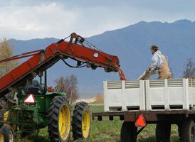
Everyone in the Valley agrees that Alaska is a great place to farm because of the cooler temperatures. VanderWeele said this is because the climate reduces the amount of pesticides necessary, there is less disease, and the land is cleaner overall. With these benefits, the VanderWeele Farms are able to emphasize the care "that grows into VanderWeele crops."

VanderWeele has been a part of the Alaska Grown Program since the beginning in 1986. The sense of Alaska pride and freshness of the products is why the VanderWeeles have been supporting the Alaska Grown program for so long. VanderWeele Farms would like to see more support from local wholesalers, but regardless, he says it is very "satisfying to grow crops for fellow humans."

http://www.alaskagrown.org/shopEat/onFarm/index.html

Slightly less than half of Alaskans live in the Greater Anchorage–Kenai Peninsula area. This region is known for its milder temperatures, proximity to the sea, ice-free ports, and petroleum and natural gas development. It is also the centre of air, road, and rail transportation and the headquarters of Alaska’s major banks, corporations, and federal and state administrative agencies.


Settlement patterns

About one-seventh of the population lives in the Greater Fairbanks area, including the town of Delta Junction, historically the centre of gold mining and the terminus of the Alaska Railroad, which runs from Seward to Fairbanks. The larger cities of the south coastal archipelago and the Gulf of Alaska islands—Ketchikan, Petersburg, Sitka, and Juneau—and surrounding areas collectively contain about one-fourth of Alaska’s population and are fishing and tourism centres.

About one-fifth of Alaskans live in small communities situated along rivers, highways, or the coast. Many of these are in Arctic and western Alaska, where the major settlements include Barrow (at Point Barrow), Kotzebue, Nome, Bethel, Dillingham, Kodiak, and Unalaska—all of which experienced significant population growth in the last quarter of the 20th century. Barrow is the major hub of the North Slope as well as the northernmost town in the United States, and it has derived significant tax revenues from Prudhoe Bay oil.

http://www.britannica.com/EBchecked/topic/12252/Alaska/79216/Settlement-patterns

State calls for village wind farms

In the coastal tundra village of Kongiganak, some residents are keeping their lights on this winter by promising to sign over future tax refunds.
Click to enlarge

But the persistent Bering Sea winds that drive up the cost of light and heat in impoverished Western Alaska are now bringing a promise of redemption as well.

Last week the state proposed spending $14 million to erect wind farms in six villages on the Yukon-Kuskokwim Delta, including Kongiganak. It's part of a plan for spending $100 million on renewable energy around Alaska to reduce consumption of expensive diesel fuel and bring down local electric bills.

"The wind turbine is a blessing for us," Harvey Paul, general manager of the local power company, Puvurnaq, said Monday. "We have some of the highest fuel prices in the state and some of the best winds."

No longer will seal hunters have to complain when rough weather keeps their skiffs on the beach, Paul said. "Now they'll stay home and enjoy the wind and be happy that their electric rates are going down."

The problems in rural Alaska posed by high energy costs and a poor fishing season swept into the news this month with dramatic reports from Emmonak and nearby villages on the Yukon delta. Some critics accused the state of being slow to respond to a humanitarian crisis.

But last year, with oil prices soaring, the Legislature did take aim at the long-term with the Renewable Energy Fund. Lawmakers committed $50 million for the first year, then added another $50 million during a special session on energy.

The six delta wind projects are on a list of 72 renewable energy priorities recommended by the Alaska Energy Authority last week. The list also includes wind projects around Nome and Kotzebue, wood-burning boilers in the Interior, small hydro feasibility studies and help for Railbelt utilities.

The priority recommendations must be approved in the next few weeks by the Legislature, which must also decide whether to continue funding the program at a recommended pace of $50 million a year.

http://www.adn.com/news/alaska/rural/story/668494.html