Chapter 9: The Changing South

Alaska's Heritage

Although people have lived in Alaska for at least 15,000 years, the first written accounts regarding the inhabitants are less than 300 years old. Much of what we know of the inhabitants who lived in Alaska thousands of years ago is based on archaeological evidence and is called prehistory. Other sources of information, particularly about the inhabitants of Alaska before Euroamericans arrived, are based on oral traditions of Alaska's Natives. The period for which these additional sources originated is called protohistory. Cultural information and physical evidence are studied to discover how people lived in the past. The prehistoric and protohistoric records form a base to which we add more recent oral traditions and written records that document Alaska's historical past.

Artifacts tell how Alaskans lived

A chipped stone, a jade knife blade, a bit of copper can suggest how prehistoric Alaskans lived. Archaeologists look for these traces of the past. Sometimes they find places where earlier people stopped to build homes, catch salmon, or butcher whales. By examining such small details as the shape of a harpoon point or the etching on a pebble, these students of the past can describe how the hunters and fishers lived thousands of years ago. They can tell what other prehistoric people were related to early Alaskans. By studying the layers of soil, animal bones from old living places, and other information they can tell what the climate was like, what plants were cultivated, and what animals were hunted by prehistoric people.

Despite the archaeologists' skills, conclusions about Alaska's prehistory are incomplete. Many traces of early habitation have been found throughout Alaska, but only a few archaeological sites have been thoroughly studied. As more sites are closely examined, the story of Alaska's early people will become more detailed and accurate.

First hunters reach Alaska

The ancestors of Alaska's Indians, Eskimos, and Aleuts probably entered North America from Asia across a land bridge that was part of Beringia. Some might have come earlier over a smaller land bridge. Between 25,000 and 9,000 years ago, when sea level was much lower that it is today, land connected Alaska and Siberia. The bridge extended 1,000 miles north and south from the Gulf of Anadyr on Siberia's northeast coast to the western end of Umnak Island in the Aleutian Islands. Hundreds of years passed as people lived on the land bridge and moved across it from Asia to North America. Alaska was the first part of North America these people came to. Some of the people who crossed, particularly those who came more recently, settled permanently in Alaska.

Currently, some archaeologists think that there were three major migrations of people to Alaska. The migrations involved different groups of people and occurred thousands of years apart. The first migration occurred at least 15,000 years ago and possibly more than 25,000 years ago. These early immigrants are the ancestors of most Indian tribes in North and South America. The second group of immigrants are the ancestors of the Tlingits, Eyaks, and Athabaskans of Alaska and the Navaho and Apache people of the American Southwest. They moved from the northeastern forests of Siberia perhaps 9,000 to 14,000 years ago. The last group of immigrants moved about 6,000 to 10,000 years ago and some perhaps as recently as 4,000 years ago. They are the ancestors of the Eskimos and Aleuts. They came from the coast of northeast Siberia.

The oldest sites of proven human occupation in Alaska date back 11,000 years. One early site is Onion Portage, located on the Kobuk River in Northwest Alaska. Different groups of people lived at this site for thousands of years. The tools excavated from the most ancient soil layers are similar to those found in Siberia. They are the kind of tools that would have been used to cut meat, scrape hides, work wood, or make weapons.

On the Seward Peninsula, broken bones of bison and horses in Trail Creek Caves indicate humans were there as early as 11,000 years ago and possibly as early as 15,000 years ago. Early occupants probably hunted elk, horse, and caribou. They might also have worked and sewed skins.

In Interior Alaska archaeologists have found evidence at Healy Lake and Dry Creek, both north of the Alaska Range, that groups of people were there as early as 11,000 years ago. They were chiefly hunters and followed the caribou herds. In Southeast Alaska, Groundhog Bay in Icy Strait and Hidden Falls on Baranof Island near Sitka were probably campsites 8,000 years ago. The people gathered materials near these sites to make scraping and chopping tools. They fished and collected shellfish along the shore.

In the Aleutian Islands there is evidence that people lived together in a village there at least 8,500 years ago. The people at Anangula made pointed blades and scrapers, weights for fishing lines, and stone lamps and dishes. They made their living from the sea.

Territorial boundaries are established

By the mid-1700s between 60,000 and 80,000 people lived in Alaska. They included three separate groups of people: Indians, Aleuts, and Eskimos.

The Indians included the Tlingits and Haidas who lived in Southeast Alaska and the Athabaskans who lived in Interior Alaska. The Tlingits and Haidas numbered about 10,000 in the mid-1700s. The Alaskan Athabaskan population was about as large, but these people occupied an area about eight times larger than that occupied by the Tlingits and Haidas.

The Aleuts inhabited the Aleutian Islands and part of the Alaska Peninsula in Southwest Alaska. They numbered around 15,000 when the Euroamericans (people from Europe or European colonies in America) arrived.

The Eskimos lived along the Alaska coast from the Arctic Ocean to the northern boundary of Southeast Alaska near Yakutat. Eskimo territory included the tundra regions along the northern and western Alaska coast, Kodiak Island, part of the Alaska Peninsula, and Prince William Sound. The Eskimo population totaled around 30,000 by the mid-1700s.

Languages reflect changing cultures


Alaska Native languages.
All of the languages but two found i n Alaska today are related to two major language families. These two families are Eskimo-Aleut and Athabaskan-Eyak-Tlingit. The exceptions are Haida and Tsimshian. These are both languages of Native groups who lived in the Pacific Northwest. Eleven Athabaskan-Eyak-Tlingit languages are still spoken in Alaska. Eskimo-Aleut languages still spoken are Alutiia, Central Yupik, Siberian Yupik, Inupiaq, and Aleut. There were other languages and variations that have become lost over the millenniums.

Cultures share common customs

By the 1700s when Euroamericans arrived in Alaska, the Tlingits, Haidas, Athabaskans, Eskimos, and Aleuts had defined territorial boundaries. They had a few common traits. They all were hunters and gatherers. They had no agriculture and only one domesticated animal, the dog. Each group had its own well established annual subsistence cycle based on the seasons and availability of animals and fish. Oceans, rivers, and lakes were their principal travelways and all of the groups had some kind of boat.

Shamans were important in each culture. This person, man or woman, looked after both the physical health and spiritual needs of the villagers. Shamans were the intermediaries between people and the spirit world.

A person's importance was often measured by his or her wealth. It might be represented by blankets, slaves, or other kinds of property. People acquired wealth not to keep, but to distribute to others. The rich gave away their wealth during Tlingit potlatches, Athabaskan festivals, Eskimo messenger feasts, and Aleut theatrical gatherings. These different ceremonies had the same purposes: to share wealth with the less fortunate and to obligate others to give gifts in return.

All Alaska Native groups expressed themselves artistically through earrings, face painting, labrets, tattooes, and decorated clothing. The people used whatever materials were at hand including wood, bone, stone, ivory, antler, feathers, porcupine quills, animal teeth, shells, and grasses. Dyes were made from berries, roots, and minerals.

Each group of Native Alaskans looked on itself as the center of the universe. Their names for themselves meant "the real people." Their explanations of the world included traditions of a supernatural being, usually Raven, as the creator of the world.

Native Alaskans also traded among themselves for things they needed. Trade fairs and trade trails connected interior people with coastal groups. In addition, some Euroamerican trade items, such as iron knives, passed from Native groups living outside Alaska to Native Alaskans before the Euroamericans themselves arrived.

http://www.akhistorycourse.org/articles/article.php?artID=148Alaska Native Heritage Center
ATHABASCANS

Who We Are

The Athabascans traditionally lived in Interior Alaska, an expansive region that begins south of the Brooks Mountain Range and continues down to the Kenai Peninsula. There are eleven linguistic groups of Athabascans in Alaska. Athabascan people have traditionally lived along five major river ways: the Yukon, the Tanana, the Susitna, the Kuskokwim, and the Copper river drainages. Athabascans were highly nomadic, traveling in small groups to fish, hunt and trap.

Today, Athabascans live throughout Alaska and the Lower 48, returning to their home territories to harvest traditional resources. The Athabascan people call themselves ‘Dena,’ or ‘the people.’ In traditional and contemporary practices Athabascans are taught respect for all living things. The most important part of Athabascan subsistence living is sharing. All hunters are part of a kin-based network in which they are expected to follow traditional customs for sharing in the community.

House Types and Settlements

The Athabascans traditionally lived in small groups of 20 to 40 people that moved systematically through the resource territories. Annual summer fish camps for the entire family and winter villages served as base camps. Depending on the season and regional resources, several traditional house types were used.

Tools and Technology

Traditional tools and technology reflect the resources of the regions. Traditional tools were made of stone, antlers, wood, and bone. Such tools were used to build houses, boats, snowshoes, clothing, and cooking utensils. Birch trees were used wherever they were found.

Social Organization

The Athabascans have matrilineal system in which children belong to the mother's clan, rather than to the father's clan, with the exception of the Holikachuk and the Deg Hit'an. Clan elders made decisions concerning marriage, leadership, and trading customs. Often the core of the traditional group was a woman and her brother, and their two families. In such a combination the brother and his sister's husband often became hunting partners for life. Sometimes these hunting partnerships started when a couple married.

Traditional Athabascan husbands were expected to live with the wife's family during the first year, when the new husband would work for the family and go hunting with his brothers-in-law. A central feature of traditional Athabascan life was (and still is for some) a system whereby the mother's brother takes social responsibility for training and socializing his sister's children so that the children grow up knowing their clan history and customs.

Clothing

Traditional clothing reflects the resources. For the most part, clothing was made of caribou and moose hide. Moose and caribou hide moccasins and boots were important parts of the wardrobe. Styles of moccasins vary depending on conditions. Both men and women are adept at sewing, although women traditionally did most of skin sewing.

Transportation

Canoes were made of birch bark, moose hide, and cottonwood. All Athabascans used sleds --with and without dogs to pull them – snowshoes and dogs as pack animals.

Trade

Trade was a principle activity of Athabascan men, who formed trading partnerships with men in other communities and cultures as part of an international system of diplomacy and exchange. Traditionally, partners from other tribes were also, at times, enemies, and travelling through enemy territory was dangerous.

Regalia

Traditional regalia varies from region to region. Regalia may include men’s beaded jackets, dentalium shell necklaces (traditionally worn by chiefs), men and women’s beaded tunics and women’s beaded dancing boots.

http://www.akhistorycourse.org/articles/article.php?artID=193

Chapter 8: Appalachia And The Ozarks

Mining

Alaska often conjures up images of gold - prospectors, miners and adventurers combing the creeks of the Interior searching for the next big discovery. The town of Fairbanks, and many of its surrounding communities, among them Ester, Fox and Chatanika, were founded because of placer gold discoveries on local creeks in the early 1900's. However, the communities that survived into this century survived because their economies diversified away from gold production; others - such as Meehan and Cleary - withered and died when the miners pulled out.


Alaska's Mineral Wealth


Gold and the stampedes it caused were critical factors in the European settlement of Alaska. Therefore, gold is the metal most often associated with this state's mineral resources.


However, Alaskan geology also hosts some of the world's largest and richest deposits of lead, zinc, silver and copper. Kennecott - one of the world's largest mining companies, got its start here with the Kennecott Copper mine (now a National Park) in the Wrangell Mountains, which mined one of the richest copper deposits ever found. And Teck-Cominco's Red Dog mine, located in the DeLong Mountains 50 miles northeast of the Native Village of Kivalina, currently holds the position as the world's largest lead-zinc mine. Platinum has also been mined here, and there are ongoing searches for the diamonds and sapphires that many prospectors are convinced lie undetected in stream gravels.

Modern Metal Mining in Alaska


While metal mining does occur in southeast Alaska (Greens Creek and Kensington mines, for example), and to a limited extent
in south-central, the Interior and Arctic regions are the primary targets for the new mineral boom currently underway in the state. Started in the early 1980's, with the development of Red Dog, which is estimated to hold 25 million tons of zinc, and fanned to a fever pitch by the discoveries of the Fort Knox gold deposit near Fairbanks and the Pogo gold deposit near Delta, the last 20 years have seen rapid and aggressive claim staking and exploration by mining companies.

Additionally, during that time, in Interior and Arctic Alaska, six hardrock mines came into production - Ryan Lode (closed in 1993) Red Dog, Fort Knox and True North, Illinois Creek (now bankrupt) and Nixon Fork (closed due to falling gold prices). While these mines varied in size, from the quite small Ryan Lode, with a reserve of about 100,000 ounces of gold, to the very large Fort Knox mine, with, at time of permitting, 5. 2 million ounces of gold, to the gargantuan Red Dog, what was common to all of them was the modern mining technologies that set them apart from the placer mining process that used to be the hallmark of Alaskan mining.

The Costs of Mining


Although Alaska mining law requires reclamation of mine sites, the impacts of bulk-tonnage mining are impossible to eradicate after mine closure. A mine site may be returned to functionality as wildlife habitat or recreational area, but the process takes decades. Acceptable reclamation may also be thwarted by ongoing environmental degradation, such as impacts to water quality from heavy metal leaching, which was not accounted for in the original mine/reclamation plan. For example, open pits are rarely filled in at closure; instead, groundwater is allowed to seep back into the pit, eventually creating a pit lake. Unfortunately, the heavy metals and salts that are typically associated with mineral deposits also end up in the water, so that perpetual water treatment is necessary if the lake were to be used for aquatic habitat or recreational purposes.
To date, in Alaska, no open pit mine has undergone complete reclamation or has been released by regulatory agencies as a completed, reclaimed mine project.


http://www.northern.org/artman/publish/mining.shtml


Chapter 7: The Bypassed East

Population distribution

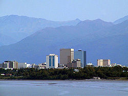
Anchorage is the largest city in Alaska.

Anchorage is the largest city in Alaska.

Alaska is the least densely populated state in the U.S. with 0.4247 people per square kilometer (1.1 per square mile). Population densities in the other states range from 1.97 per square kilometer (5.1 per square mile) in Wyoming to 438 per square kilometer (1,134.4 per square mile) in New Jersey. Alaska's population was estimated to be 663,661 in 2005.

Alaska's most populous city is Anchorage, home to 277,000 people (2007 estimate)—42 percent of the state's population. The city comprises 5,063 sq. kilometers (1,955 sq. miles)—about the size of the land area of the state of Delaware.[28]

In 2007, Alaska had more than three times the people and five times the jobs it had when it became a state in 1959. More than 60 percent of the population lives in Anchorage and adjacent boroughs. Many of the Alaska natives continue to live in remote villages scattered throughout the state, generally along rivers or the coasts. The lifestyles of those in the cities and those in rural areas are vastly different. Many in the remote areas survive on subsistence farming and fishing and must contend with a lack of safe water and sewer systems. Unemployment in these areas tends to be quite high.

The vast, sparsely populated regions of northern and western Alaska are primarily inhabited by Alaska Natives, who are also numerous in the southeast. Anchorage, Fairbanks, and other parts of south-central and southeast Alaska have many whites of northern and Western European ancestry. The Wrangell-Petersburg area has many residents of Scandinavian ancestry and the Aleutians contain a large Filipino population. Most of the state's black population lives in Anchorage. Fairbanks also has a sizable African American population.

Agriculture and manufacturing

Agriculture represents only a small fraction of the Alaska economy. Agricultural production is primarily for consumption within the state and includes nursery stock, dairy products, vegetables, and livestock. Manufacturing is limited, with most foodstuffs and general goods imported from elsewhere.

Environmentalism

Oil production was not the only economic value of Alaska's land, however. In the second half of the twentieth century, Alaska discovered tourism as an important source of revenue, which had become popular following World War II, when men stationed in the region returned home praising its natural splendor. The Alcan Highway, built during the war, and the Alaska Marine Highway System, completed in 1963, made the state more accessible than it had ever been. Tourism became increasingly important in Alaska, and today over 1.4 million people visit the state each year.

With tourism more vital to the economy, environmentalism also rose in importance. The Alaska National Interest Lands Conservation Act (ANILCA) of 1980 added 53.7 million acres (217,000 km²) to the National Wildlife Refuge system, parts of 25 rivers to the National Wild and Scenic Rivers system, 3.3 million acres (13,000 sq km) to National Forest lands, and 43.6 million acres (176,000 sq km) to National Park land. Because of the Act, Alaska now contains two-thirds of all American national park lands. Today, more than half of Alaskan land is owned by the Federal Government.

Exxon-Valdez

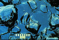
Oil pooled on rocks on the shore of Prince William Sound after the oil spill.

Oil pooled on rocks on the shore of Prince William Sound after the oil spill.

The possible environmental repercussions of oil production became clear in the Exxon Valdez oil spill of 1989. On March 24, the tanker Exxon Valdez ran aground in Prince William Sound, releasing 11 million gallons (42 million liters) of crude oil into the water, spreading along 1,100 miles (1,800 km) of shoreline. According to the U.S. Fish and Wildlife Service, at least 300,000 sea birds, 2,000 otters, and other marine animals died as a result of the spill. Exxon spent $2 billion on cleaning up in the first year alone. Exxon, working with state and federal agencies, continued its cleanup into the early 1990s. Government studies show that the oil and the cleaning process itself did long-term harm to the ecology of the Sound, interfering with the reproduction of birds and animals in ways that still aren't fully understood. Prince William Sound seems to have recuperated, but scientists still dispute the extent of the recovery. In a civil settlement, Exxon agreed to pay $900 million in ten annual payments, plus an additional $100 million for newly discovered damages.

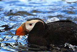
Tufted Puffin at the Alaska SeaLife Center.

Tufted Puffin at the Alaska SeaLife Center.

The Alaska SeaLife Center, which opened in May 1998, was established by The Seward Association for Advancement of Marine Science and continues as a collaborative effort between Coastal America, North Pacific Research Board, University of Alaska School of Fisheries and Ocean Sciences, and Ocean Alaska Science & Learning Center.

The Exxon Valdez Oil Spill Settlement Fund provided $26 million to help build the $56 million facility. Grants, bonds and donations supplied the remaining funds, while the city of Seward donated a seven-acre waterfront site.

The center is dedicated to understanding and maintaining the integrity of the marine ecosystem of Alaska through research, rehabilitation, and public education. Visitors are immersed in naturalistic exhibits relating to the marine ecosystems of the state.

Arctic National Wildlife Refuge

Today, the tension between preservation and development is seen in the Arctic National Wildlife Refuge (ANWR) drilling controversy. The question of whether to allow drilling for oil in ANWR has been a political football for every sitting American president since Jimmy Carter. Studies performed by the U.S. Geological Survey have shown that the "1002 area" of ANWR, located just east of Prudhoe Bay, contains large deposits of crude oil.

Traditionally, Alaskan residents, trade unions, and business interests have supported drilling in the refuge, while environmental groups and many within the U.S. Democratic Party have traditionally opposed it. Among native Alaskan tribes, support is mixed. In the 1990s and 2000s, votes about the status of the refuge occurred repeatedly in the U.S. House and Senate, but as of 2007, efforts to allow drilling have always been ultimately thwarted by filibusters, amendments, or vetoes.

http://www.newworldencyclopedia.org/entry/Alaska#Agriculture_and_manufacturing

Chapter 6: Canada's National Core

Land ownership and protected lands

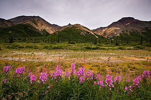
Unspoiled nature in Alaska.

Unspoiled nature in Alaska.

The Arctic National Wildlife Refuge in the northeast corner of Alaska covers 19,049,236 acres (77, 090 sq km). Much of the northwest Arctic coastal area west of the Colville River is included in the National Petroleum Reserve–Alaska, which covers about 23,000,000 acres (93,100 km²). The land between these two set-aside areas has seen considerable oil and gas exploration, the establishment of an oil extraction industry centered on the Prudhoe Bay, and the construction of an oil pipeline and access road heading south.

According to an October 1998, report by the United States Bureau of Land Management, approximately 65 percent of Alaska is owned and managed by the U.S. federal government as national forests, national parks, national wildlife refuges, national wild and scenic rivers, and national conservation areas. Among these, the Bureau of Land Management manages 87 million acres (350,000 sq km), or 23.8 percent of the state, which area includes the National Petroleum Reserve–Alaska. The Arctic National Wildlife Refuge is managed by the United States Fish and Wildlife Service.

The remaining 35 percent of the state land area is apportioned between the State of Alaska (24.5 percent) and thirteen regional (and dozens of local) Native corporations created under the Alaska Native Claims Settlement Act (10 percent), and various private interests (less than 1 percent).

Culture

Some of Alaska's popular annual events are the World Ice Art Championships in Fairbanks, the Blueberry Arts Festival in Ketchikan, the Sitka Whale Fest, and the Stikine River Garnet Fest in Wrangell. The Stikine River features the largest springtime concentration of American Bald Eagles in the world.

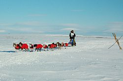
Musher Robert Sorlie near the Nome finish of the Iditarod.

Musher Robert Sorlie near the Nome finish of the Iditarod.

Various dog mushing races are held around the state, but the best known is the Iditarod Trail Sled Dog Race, following a 1,150 mile (1850 km) trail from Anchorage to Nome. The race commemorates the famous 1925 serum run to Nome in which mushers and dogs like Balto took much-needed medicine to the diphtheria-stricken community of Nome when all other means of transportation had failed. Portions of the original Iditarod Trail were used by the Native American Inuit and Athabaskan peoples hundreds of years before the arrival of Russian fur traders in the 1800s, but use of the trail reached its peak between the late 1880s and the mid 1920s as miners arrived to dig coal, and later, gold. Mushers from all over the world come to Anchorage each March to compete for both cash prizes and prestige.

The Alaska Native Heritage Center celebrates the rich heritage of Alaska's eleven cultural groups. The center's purpose is to enhance self-esteem among Native people and to encourage cross-cultural exchanges among all people.

Alaska's two professional sports teams are the Alaska Aces, an ECHL hockey team, and the Alaska Wild, a new Intense Football League football team.

Hiking, camping, and cross-country skiing, as well as hunting and fishing, are all very popular in Alaska.

http://www.newworldencyclopedia.org/entry/Alaska#Land_ownership_and_protected_lands

Chapter 5: The North American Manufacturing Core

Relative location of Alaska

Alaska is positioned in both the eastern, northern and western
hemispheres.
Dissected by the
Arctic Circle, it's located in the far northwestern corner of North America, bordering the Canadian province of British Columbia and Canada's Yukon Territory.

It's ringed by the Arctic Ocean, Pacific Ocean, and assorted bays, gulfs, seas and sounds.

Alaska's largest city bustles with adventure

Anchorage

From its early days as a railroad camp in a spruce and birch forest, Anchorage has grown into Alaska's largest city and the gateway for many visitors.

Anchorage is a modern city in a beautiful setting -- laid out between the Chugach Mountains and Cook Inlet, and within sight of Mount McKinley, the continent's tallest peak.

The city has its share of asphalt and tall buildings, but nature still runs wild. Spawning salmon migrate up Anchorage's streams, and anyone walking through the woods may come face to face with a moose.

Anchorage was created as a railroad construction camp on Ship Creek in 1914. It grew quickly during World War II and in the pipeline construction boom of the 1970s. The 1964 Prince William Sound earthquake, with a magnitude of 9.2, severely damaged parts of Anchorage. The city healed quickly and is the financial, cultural and medical capital of Alaska.


http://www.alaska.com/places/story/2101.html

Chapter 4: Megalopolis

2007 Population for Alaska Released
Southeast region continued to have largest overall population decline

Alaska's statewide population increased 7.9 percent, or 49,454 people, from 2000 to 2007, based on new population estimates released Friday by the Alaska Department of Labor and Workforce Development.

Alaska's growth was slightly faster than the 6.9 percent increase for the United States as a whole during the seven-year period. (Unless otherwise indicated, all population estimates have a reference date of July 1. The 2007 estimates are provisional.)

The number of people living in Alaska climbed from 627,533 in 2000 to 676,987 in 2007 (See Table 1). Alaska's average annual rate of population change was 1.1 percent during the 2000-2007 period and 0.9 percent for the 2006-2007 period. Alaska is still the 47th most populous state, and is larger than North Dakota, Vermont, the District of Columbia and Wyoming.

Currently, growth in Alaska as a whole is primarily through natural increase. From 2000 to 2007, Alaska's natural increase (births minus deaths) added 50,486 people, while net-migration (in-migration minus out-migration) accounted for a loss of 1,032 people. During the 2006-2007 period, Alaska added 7,756 people through natural increase and lost 1,727 people to net out-migration.

In the early 1990s, Alaska added an average of 8,100 people each year through natural increase. A gradual decline in births and a gradual increase in deaths - both tied to an aging population - have resulted in a slowdown in natural increase to about 7,300 people a year.

When international and domestic migration are considered separately, the loss of 1,727 migrants between 2006 and 2007 breaks down to a gain of 602 international migrants and a loss of 2,329 domestic migrants. Thus, international migration is currently compensating for some of the outward domestic migration. About 70,000 people now migrate to and from Alaska each year. In- and out-migration are nearly equal at about 35,000.

"It is important to note that, because our estimates are for resident population, any troops deployed overseas are counted as being in Alaska in our estimates," said Greg Williams, state demographer. "This means that the populations for the Fairbanks North Star Borough and the Municipality of Anchorage, where the main Alaska military bases are located, as well as other communities with a substantial National Guard presence, may be somewhat lower than these estimates indicate, depending on the current deployment of military and National Guard personnel."

Boroughs and Census Areas

Department of Labor population estimates have also been released for Alaska's 28 boroughs and census areas (see Table 2), as well as for 343 places located throughout the state. Unlike Table 1, which considers population change from the average annual population in 2000, Table 2 considers population change from the April 1, 2000 U.S. Census.

Table 2
Population of Alaska by Labor Market, Area,
Borough and Census Area,
1990-2007
Click on the Table 2 for a larger graphic.

Most of Alaska's boroughs and census areas grew slowly or lost population between the 2000 Census and 2007. Of the 28 boroughs and census areas, 10 gained population between 2000 and 2007. The largest population increases occurred in the Municipality of Anchorage (+23,540), Matanuska-Susitna Borough (+20,734), Fairbanks North Star Borough (+8,123), Kenai Peninsula Borough (+2,679), Southeast Fairbanks Census Area (+848), Bethel Census Area (+786) and Wade Hampton Census Area (+567).

Population growth in the Municipality of Anchorage and the Mat-Su Borough accounted for roughly 76.5 percent of the growth in those 10 boroughs and census areas. The Municipality of Anchorage made up 40.7 percent of the growth, with population gains in the Mat-Su Borough making up 35.8 percent.

The Mat-Su Borough continued in 2007 to be the fastest-growing area in the state, as it has been since 1990. Between 2000 and 2007, it grew at an average annual rate of 4.1 percent, which is slightly greater than its 4.0 percent annual growth rate during the 1990s. However, its growth slowed to 3.5 percent between 2006 and 2007.

The increases in both the Municipality of Anchorage and the Mat-Su Borough in the 2000-2007 period were due to a mix of natural increase and net-migration. A substantial part of migration to Anchorage comes from other parts of Alaska.

The Mat-Su Borough was the only area of the state where growth came primarily from net in-migration. Since the 2000 Census, net in-migration accounted for 16,030 of the Mat-Su Borough's population increase of 20,734.

The majority of Mat-Su's migration comes from the Municipality of Anchorage. Those two areas, plus the Southeast Fairbanks Census Area (+408) and Kenai Peninsula Borough (+245), were the only areas where in-migration noticeably exceeded out-migration during the 2000-2007 period.

In the more recent 2006-2007 period, Anchorage gained a total of 579 people, while the Mat-Su Borough gained 2,782 people. And while Anchorage had a current natural increase of 3,350 compared to the Mat-Su Borough's 822, Mat-Su gained 1,960 migrants and Anchorage lost 2,771.

Eighteen boroughs and census areas lost population between 2000 and 2007. The Southeast region continued to have the largest overall decline, losing 5.1 percent of its population since 2000, with a natural increase of 3,650 people and a net out-migration of 7,404 people. No Southeast area had long-term growth between 2000 and 2007.

http://www.sitnews.us/0208news/021008/021008_ak_population.html

Chapter 3: Foundations of Human Activity

Culture of Alaska

Although Alaska became part of the United States in 1867, early Alaska history begins in the Paleolithic period. Alaska history books tell us that the earliest Alaskan inhabitants were of Asiatic decent. The population was divided into three categories: honorables, which included the respected whalers and elders; common people; and slaves. The honorables were mummified at death. Occasionally, a slave was killed in honor of the deceased.

Most of the documented Alaska history dates back to the European settlement, when a Danish navigator aboard a Russian ship discovered the territory in 1741.When the crew returned to Russia, they brought with them some of the finest otter furs in the world. When Alaska became a Russian hunting and trading post, Catherine the Great urged the hunters to treat the Native Aleuts with compassion. However, the hunters’ obsessive quest for furs made this impossible. The next years in Alaska State history were characterized by conflicts with the Native American indigenous people.

Meanwhile, King Charles the III of Spain was none too pleased with this Russian expansion. Between the years 1774 and 1791, he sent out a few expeditions to the area. Eventually, Charlie decided that both the Russians and the Natives were formidable enemies. As a result, he abandoned his efforts at trying to claim any of Alaska’s territory for Spain.

During this time frame, the British also tried to claim a piece of the action. When Captain James Cook set sail to explore the Alaskan territory in 1778, his crew was also impressed by the possible uses for the sea otters. When they returned to England to show off their newly-killed fur coats, the British decided to send out more expeditions to Alaska. As a result, the town of Wrangell became subject to British rule.

The next important Alaska State history event occurred on April, 9 1867 when United States Secretary of State William H. Seward engineered the purchase of Alaska from the Russians for 7.2 million dollars. For years, the Alaskan territory would become a major gold rush site.

Then, on July 7th, 1958 President Dwight D. Eisenhower signed the Alaska Statehood Act. This crucial event in Alaska State history paved the way for Alaska’s admission as the 49th State on January 3rd, 1959. In the years that followed the quest for an Alaskan culture would inspire indigenous groups to play an active role in their state and local government. Native American groups became united in their quest to claim title to the areas that were stolen form them. The government took their time in responding to these claims until oil was discovered at Prudhoe Bay on the Arctic coast. So that they could lessen the difficulty of drilling at a remote location and transporting the oil to the lower 48 states, the government decided to build a pipeline that would carry the oil across Alaska to the port of Valdez. At Valdez, the oil would be loaded onto tanker ships and sent to the lower 48 states.

Although the plan was approved, the permit to construct the pipeline was denied. However, there was a caveat. The pipeline would cross the lands that were involved in the Alaskan culture argument. The Alaskan culture dispute needed to be settled before the pipeline could be built. Since petroleum dollars were now on the line, in 1971, the Alaska Native Claims Settlement Act was signed. The Native Americans relinquished aboriginal claims to their lands in exchange for 44 million acres of land in other parts of Alaska. They were also paid 963 million dollars. As a result, Native American Alaskan culture is alive and well, and can be seen all throughout the state.

http://www.destination360.com/north-america/us/alaska/alaska-history.php

Chapter 2: The Physical Environment

Climate of Alaska

TOPOGRPHIC FEATURES Alaska is the westernmost extension of the North American Continent. Its east-west span covers a distance of 2,000 miles, and from north to south a distance of 1,100 miles. The State’s coastline, 33,000 miles in length, is 50 percent longer than that of the conterminous United States. In addition to the Aleutian Islands, hundreds of other islands, mostly undeveloped, are found along the northern coast of the Gulf of Alaska, the Alaska Peninsula, and the Bering Sea Coast. Alaska contains 375 million acres of land and many thousands of lakes.

There are 12 major rivers plus three major tributaries of the Yukon, all of which drain two-thirds of the State. Four rivers, the Yukon, Stikine, Alek, and Taku, can be classed as major international rivers.

The two longest mountain ranges are the Brooks Range which separates the Arctic region from the interior and the Alaska-Aleutian Range which extends westward along the Alaska Peninsula and the Aleutian Islands, and northward about 200 miles from the Peninsula, then eastward to Canada. Other shorter but important ranges are the Chugach Mountains which form a rim to the central north Gulf of Alaska, and the Wrangell Mountains lying to the northeast of the Chugach Range and south of the Alaska Range. Both of these shorter ranges merge with the St. Elias Mountains, extending southeastward through Canada and across southeastern Alaska as the Coast Range. Numerous peaks in excess of 10,000 feet are found in all but the Brooks Range. The highest peak (20,320 feet above sea level) in the North American Continent, Mt. McKinley, is located in south-central Alaska. Many other peaks tower above 16,000 feet; however, nearly all of the inhabited sections of the State are at 1,000 feet elevation or less.

Permafrost is a major factor in the geography of Alaska. It is defined as a layer of soil at variable depths beneath the surface of the earth in which the temperature has been below freezing continuously from a few several thousands of years. It exists where summer heating fails to penetrate to the base of the layer of frozen ground. Permafrost covers most of the northern third of the State. Discontinuous or isolated patches also exist over the central portions in an overall area covering nearly a third of the State. No permafrost exists in the south-central and southern coastal portions including southeastern Alaska, the Alaska Peninsula, and the Aleutian chain.

CLIMATIC ZONES – The geographical features already mentioned have a significant effect on Alaska’s climate, which falls into five major zones. Reference is made to the section of maps at the back, specifically to the map showing geographical subdivisions of Alaska. The climate zones are: (1) a maritime Zone which includes southeastern Alaska, the south coast, and southwestern islands; (2) a maritime continental zone which includes the western portions of Bristol Bay and west-central zones. In this zone the summer temperatures are moderated by the open waters of the Bering Sea, but winter temperatures are more continental in nature due to the presence of sea ice during the coldest months of the year; (3) a transition zone between the maritime and continental zones in the southern portion of the Copper River zone, the Cook Inlet zone, and the northern extremes of the south coast zone; (4) a continental zone make up of the remainders of the Copper River and west-central divisions, and the interior basin; and (5) an artic zone, shown on the map as the arctic drainage division.

PRECIPITATION – In the maritime zone a coastal mountain range coupled with plentiful moisture produces annual precipitation amounts up to 200 inches in the southeastern panhandle, and up to 150 inches along the northern coast of the Gulf of Alaska. Amounts decrease to near 60 inches on the southern side of the Alaska Range in the Alaska Peninsula and Aleutian Island sections. Precipitation amounts decrease rapidly to the north, with an average of 12 inches in the continental zone and less than 6 inches in the arctic region.

Snowfall makes up a large portion of the total annual precipitation. For example, Yakutat averages 216 inches of snow annually and has a total annual precipitation (rain plus water equivalent of snow) of about 130 inches. Along the arctic slope, Barrow receives an average of 29 inches of snow annually and a total annual precipitation of slightly more than 4 inches. Total snow depths on the ground are controlled by the temperature of an area. Fortunately, most of the areas of heavy snow have relatively mild temperatures which prevent total depths from becoming excessive. Present-day snow removal equipment is able to keep highways and airports operational.

Precipitation extremes are of interest. With reference to total amounts (both rain and snow) and based on existing records, the greatest annual precipitation occurred at MacLeod Harbor on Montague Island in the Gulf of Alaska with 332.29 inches in 1976. This station also holds the record for monthly totals with 70.99 inches in November 1976.

The record maximum for 24 hours occurred on December 29, 1955, in the city of Cordova (North Gulf of Alaska coast) with a measured amount of 14.13 inches. Snowfall extremes are all credited to a station at Thompson Pass, which is on the highway north of Valdez. The record measurements are: season (1952-53) 974.5 inches; month (February 1953) 298 inches; and 24-hour (December 1955) 62 inches.

TEMPERATURE – Mean annual temperatures in Alaska range from the low 40’s under the maritime influence in the south to a chilly 10 degrees a long the Arctic Slope north of the Brooks Mountain Range. The greatest seasonal temperature contrast between seasons is found in the central and eastern portion of the continental interior. In this area summer heating produces average maximum temperatures in the upper 70’s with extreme readings in the 90’s. The highest recorded temperature for the state is 100 degrees at Fort Yukon in June 1915. In winter the lack of sunshine permits radiation to lower temperatures to the minus 50’s and occasionally colder for two or three weeks at a time. Average winter minimums in this area are 20 to 30 degrees below zero. The coldest temperature ever recorded in Alaska was minus 80 degrees at Prospect Creek on January 23, 1971.

Elsewhere in the state, temperature contrasts are much more moderate. In the maritime zone the summer to winter range of average temperatures in from near 60 to the 20’s. In the transition zone, temperatures range from the low 60’s to near zero; in the maritime-continental zones the range is from the low 60’s to 10 below zero. The arctic slopes has a range extending form the upper 40’s to 20 below zero.

Winter temperatures play a principal role in the flow of most of Alaska’s rivers. Usually beginning in late October and extending into May (and sometimes early June for the northernmost steams), thick layers of ice form, permitting passage with all types of heavy equipment. In many areas construction work and oil exploration is done in winter because both the ground and the streams are frozen hard enough from the use of the heaviest of equipment. Several rivers cease to flow completely during the coldest months.

WIND – A normal storm track along the Aleutian Island chain, the Alaska Peninsula, and all of the coastal area of the Gulf of Alaska exposes these parts of the state to a large majority of the storms crossing the North Pacific, resulting in a variety of wind problems. Direct exposure results in the frequent occurrence of winds in excess of 50 mph during all but the summer months. Shemya, on the western end of the Aleutian Islands, has experienced winds on an estimated 139 mph (estimated because the wind recorder pen could only record up to 128 mph). Wind velocities approaching 100 mph are not common but do occur, usually associated with mountainous terrain and narrow passes. For years, strong winds have taken their toll of both merchant and fishing vessels.

An occasional storm will either develop in or move into the Bering Sea then move north or northeastward, creating strong winds along the western coastal area. Because of the low flat ground in many places along the coast, these winds will cause flooding during the time the winds are blowing onshore. Winter storms moving eastward across the southern Arctic Ocean cause winds of 50 mph or higher along the arctic coast. Except for local strong wind conditions, winds are generally light in the interior sections.

Strong winds, or in fact any wind occurring in the areas of extreme winter cold, create a definite hazard to personnel exposed for even brief periods of time. For example, (using a wind chill chart developed by the U.S. Army) a temperature of a -13°F and an accompanying wind of 15 mph equals conditions that would be experienced with a temperature of –49 °F and no wind. If the temperature is a -49° F and the winds 10 mph, the resulting equivalent temperature is -81° F.


Chapter 1: Regions and Themes

Alaska regions

  • The largest state that is divided by 5 regions.
  • Alaska can be divided into five broad regions.

Inside Passage

Southeastern Alaska is a land of forested islands and shoreline. It was settled first by Indians and then by Russian, British and American arrivals. Its busy history is one of gold mining, timber cutting and salmon fishing. Juneau, Ketchikan and Sitka are the major cities. Cruise passengers often see bears, bald eagles and whales.


Southcentral

This is a land of mountains, rugged coasts, broad forests and rivers dashing from glaciers. Anchorage, the state's largest city, is here. Its history include prospectors, salmon fishermen and the Alaska Railroad. Wildlife includes bears, bald eagles and whales.

Southcentral Alaska has the state's largest city, Anchorage, but it also has scenic wonders such as Passage Canal at Whittier.

Interior

The Interior holds North America's largest peak, 20,320-foot Denali (Mount McKinley). Vast forests of birch and spruce are warm in the summer and bitterly cold in the winter, although the long winter nights feature dazzling displays of the northern lights. Gold prospectors and missionaries at the end of the 19th century found long-established Indian settlements. Fairbanks is the region's largest city.

The Alaska Range is the Interior's defining feature. In Denali National Park, Wonder Lake reflects Mount McKinley reflects at sunset.

Western

Lush Kodiak Island, the stormy and volcanic Aleutian Islands, the legendary gold-boom town of Nome. Incredibly rich nesting grounds for migratory birds in the Yukon and Kuskokwim river drainages. The brown bears of Kodiak and Katmai. This is big country, where few roads connect far-flung towns and villages.

A recreational boat follows the channel markers leading into Iliuliuk Harbor near Unalaska's Church of the Holy Ascension. Unalaska and its companion settlement, Dutch Harbor, are in the Aleutian Islands.

Northern

Arctic Alaska covers the northern third of the state -- and only a few thousand people. Caribou and polar bears live here, sharing territory with oil companies working the North Slope. Some villagers hunt bowhead whales and live off the land, maintaining traditions 10,000 years old. In Barrow, the sun stays up for weeks during the summer, but winter brings a two-month-long night.

http://www.alaska.com/regions/